
Certified Business
With over 10,000 orders
With over 10,000 orders
 FREE SHIPPING ON ORDERS OVER $50
 FREE SHIPPING ON ORDERS OVER £45
FREE SHIPPING ON ORDERS OVER $50
FREE SHIPPING ON ORDERS OVER £45
FREE SHIPPING ON ORDERS OVER $50
FREE SHIPPING ON ORDERS OVER £45
FREE SHIPPING ON ORDERS OVER $50
FREE SHIPPING ON ORDERS OVER £45
FREE SHIPPING ON ORDERS OVER $50
FREE SHIPPING ON ORDERS OVER £45
FREE SHIPPING ON ORDERS OVER $50
FREE SHIPPING ON ORDERS OVER £45
FREE SHIPPING ON ORDERS OVER $50
FREE SHIPPING ON ORDERS OVER £45
FREE SHIPPING ON ORDERS OVER $50
FREE SHIPPING ON ORDERS OVER £45

Photo by Dan Shaeffer on Unsplash
Some landscapes reward a quick stop at an overlook. Chiricahua rewards a closer look. Walk down into its canyons, and the view changes from a distant jumble of stone to a maze of towering pillars, narrow passageways, and boulders balanced above the trail.
Chiricahua National Park became the 64th national park in the United States on October 20, 2026, when President Donald Trump signed the Chiricahua National Park Act into law. The former national monument in southeastern Arizona is now the state’s fourth national park, joining Grand Canyon, Petrified Forest, and Saguaro.
The new designation makes this an exciting time to discover the park. But the best reasons to visit have been here much longer: volcanic scenery, a remarkable meeting of habitats, Apache heritage, rewarding day hikes, and dark skies worth staying up for.
This guide explains what to see, which hiking routes to choose, where to camp, and how to plan a visit that fits your time and comfort level.
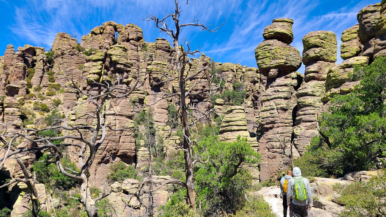
The landscape was already part of the National Park System. President Calvin Coolidge established Chiricahua National Monument in 1924, more than a century before the 2026 redesignation. National park status recognizes the area’s natural and cultural significance; it does not mean the trails and campground were newly created.
The National Park Service says hiking, camping, scenic drives, and wildlife viewing will continue. For travelers, the useful approach is to plan around the facilities and rules currently in place rather than assume the new name comes with additional services.
Some maps, booking pages, and older trail descriptions still use “Chiricahua National Monument.” They refer to the same destination. Check the official NPS designation announcement and current fees page for authoritative updates.
Chiricahua’s signature formations began with an immense volcanic eruption approximately 27 million years ago. The eruption associated with the Turkey Creek Caldera deposited hot ash and debris that compacted into rhyolite tuff.
Cracks divided the rock, and weathering and erosion gradually enlarged those fractures. Over time, the surrounding material wore away, leaving the pillars, fins, and precarious-looking balanced rocks visible today.
That history makes the hiking especially interesting. Look beyond the biggest formations and notice how the rock changes along the path: broad walls give way to slender columns, while cracks frame tiny windows of sky. The scenery is easier to appreciate when you think of it as a landscape still being shaped.
Read the NPS explanation of Chiricahua’s geology.
The Chiricahua Mountains form a “sky island”: higher, cooler mountain habitats rising above the surrounding lowlands. Within the park, grassland, desert scrub, woodland, and streamside environments occur close together. That variety helps explain why the destination appeals to wildlife watchers as well as hikers.
The area is also the homeland of the Chiricahua Apache. Its human story did not begin with a monument proclamation, a ranch, or a national park designation. Give the cultural exhibits and interpretation the same attention as the overlooks.
Faraway Ranch adds another chapter. Swedish immigrants Emma and Neil Erickson established their home here in the late nineteenth century. Their daughter Lillian and her husband Ed Riggs later developed the guest ranch, welcoming travelers who came to explore the rocks. Lillian advocated for protection of the landscape, and Ed helped develop its trail system.
A walk through this historic area offers a different perspective on the park: how people lived in the canyon and helped introduce visitors to it. Check with the visitor center for current access and tour opportunities. Explore Faraway Ranch’s history.
Willcox is the main approach for many visitors. From Interstate 10, follow Arizona Highway 186 south for approximately 32 miles, then turn onto Highway 181 and continue about four miles to the park. Tucson is a practical airport gateway; allow roughly two hours for the drive, depending on your starting point and stops.
The park has one entrance. Its paved road ends at Massai Point rather than continuing across the mountains. This matters if you are also visiting Portal or Cave Creek Canyon: a short distance on a map can involve a much longer drive.
Fuel or charge your vehicle and buy groceries, ice, and camping supplies before arrival. Services are approximately 30–40 miles away. Download directions and maps because cell reception is limited.
Vehicles over 24 feet cannot continue beyond the campground, and trailers are restricted on the upper scenic road. For an RV trip, read the official driving and vehicle guidance before choosing your vehicle or campsite.
The approximately eight-mile Bonita Canyon Scenic Drive climbs from the lower canyon toward Massai Point. It is a good introduction to the park’s changing elevation and rock scenery, especially if your group includes people who prefer overlooks and short walks.
At Massai Point, take time to study the surrounding formations before choosing a trail. The broad view helps you understand the scale of the landscape you may later walk through. A short stop can easily become longer once you start noticing individual pinnacles.
Plan this as an out-and-back drive with time for stops, rather than treating the mileage as a measure of how quickly you can finish. See Arizona’s visitor overview for more on the scenic route.

Photo by Olivia C on Unsplash
The trail network offers everything from a brief paved walk to a demanding all-day circuit. A useful first decision is whether you want a broad overlook, a walk among the pinnacles, or a longer exploration linking several canyons.
Distance note: Official NPS sources sometimes round mileage differently. The table follows the park’s 2026 hiking guide where available; longer routes vary with the starting point and connecting trails. Confirm your route against the current map before leaving.
| Hike | Approximate distance | Difficulty / best fit |
|---|---|---|
| Bonita Creek Loop | 0.2 mile loop | Easy; paved grassland walk and birding |
| Massai Point Nature Trail | 0.5 mile loop | Short interpretive walk; uneven sections and steps |
| Echo Canyon to beyond the Grotto | 1.2 miles round trip | Easy to moderate introduction to the rocks |
| Faraway Ranch to Visitor Center | 3 miles round trip | Easier lower-canyon walk via Silver Spur Meadow |
| Echo Canyon Loop | About 3.3–3.4 miles | Moderate; pinnacles, grottoes, and narrow passages |
| Sugarloaf Mountain | 1.8 miles round trip | Moderate; summit views and a steady climb |
| Natural Bridge | About 4.7–4.8 miles round trip | Moderate but demanding; repeated climbing |
| Inspiration Point | About 5.4 miles round trip | Strenuous; canyon overlook |
| Heart of Rocks from Echo Canyon or Visitor Center | About 7.4 miles round trip | Strenuous; distinctive balanced formations |
| Big Loop | Commonly 9.5 miles; variants 8.5–12 miles | Strenuous; extensive connected trail circuit |
Download the official hiking guide and map.
The 0.2-mile Bonita Creek Loop provides a short, level paved walk through grassland. It is a useful option for birdwatching or for visitors who need a less demanding outing. Under normal conditions, NPS describes the paved trail as suitable for mobility devices.
For more walking in the lower canyon, connect Faraway Ranch and the visitor center on the roughly three-mile round-trip Silver Spur Meadow route. These lower trails offer a different experience from the upper rock maze, with more emphasis on trees, history, and wildlife. Ask a ranger about current surfaces and accessibility needs.
The half-mile nature loop is a good choice when you want interpretation and views without committing to a long hike. Only part is paved, and the complete loop includes terrain that may be unsuitable for some mobility devices. Choose the section that fits your group rather than assuming the whole trail is accessible.
If you want the experience of standing beside the formations but have limited time, walk out from Echo Canyon toward the Grotto. The 2026 guide describes a 1.2-mile round trip continuing just beyond it before turning back.
Allow approximately 30–60 minutes for a short grotto visit, with extra time for photographs and careful footing. This gives you a taste of the upper trails without committing to the full loop. See the NPS grotto outing.
Echo Canyon, Hailstone, and Ed Riggs trails form a roughly 3.3–3.4-mile circuit. NPS recommends hiking counterclockwise: descend Echo Canyon, follow Hailstone, and climb back on Ed Riggs.
The route combines close-up formations, tunnel-like grottoes, narrow passages, and open views. Allow two to four hours. Although rated moderate, it has rocky steps, loose footing, exposed edges, and roughly 560 feet of elevation change.
This is our suggested first substantial hike for visitors comfortable with uneven trails. It offers variety without using the entire day. It is not suitable for wheelchairs or strollers, and pets are prohibited. Read the official Echo Canyon description.
The 1.8-mile round-trip Sugarloaf Mountain Trail climbs to a 7,310-foot summit and a historic fire lookout built by the Civilian Conservation Corps. Allow one to two hours and expect a climb of approximately 500 feet.
Choose this trail when you want to see how the canyons and formations fit together. The exposed summit also makes weather an important consideration: save it for conditions without threatening thunderstorms. Check Sugarloaf trail information.
This roughly 4.7–4.8-mile round-trip hike crosses changing habitats and repeated ups and downs before reaching an overlook. The small natural bridge is across the canyon; the trail does not lead you onto it.
Allow three to four hours. With approximately 1,000 feet or more of elevation change, it can feel harder than the “moderate” label suggests. Choose it for varied scenery and a quieter-feeling outing, rather than expecting a large arch immediately beside the path. Read the Natural Bridge route description.
The approximately 5.4-mile round-trip route links Ed Riggs, Mushroom Rock, and Inspiration Point trails. Its overlook provides views of Rhyolite Canyon and Cochise Head.
NPS rates it strenuous and suggests three to four hours. It suits hikers who want a longer outing with a clear viewpoint destination. Budget time for the return climb as well as a rest at the overlook. See Inspiration Point details.
Heart of Rocks is a destination within the trail network, not a short loop immediately beside a parking lot. Reaching it and returning generally makes a strenuous hike of approximately 7.4 miles.
From Echo Canyon, follow Ed Riggs, Mushroom Rock, and Big Balanced Rock trails to the Heart of Rocks area. From the visitor center, use Lower Rhyolite Canyon and Sarah Deming trails. The visitor-center approach involves a substantial climb.
Follow the signed Heart of Rocks loop clockwise. Rocky steps and boulders require attention, and the unusual formations invite frequent stops. Allow at least four to six hours, and longer if your pace or chosen approach requires it. Start early. Compare the official Heart of Rocks approaches.
The commonly described 9.5-mile Big Loop links Echo Canyon, Upper Rhyolite Canyon, Sarah Deming, Heart of Rocks, Big Balanced Rock, Inspiration Point, Mushroom Rock, and Ed Riggs trails.
This is a strenuous option for hikers who want a broad exploration. NPS lists four to seven hours for the standard route, while the current hiking guide describes variants between 8.5 and 12 miles. Ask a ranger to help confirm the exact combination you intend to walk.
Choose it because the distance, weather, and daylight suit your group. If you prefer longer breaks and photography stops, a shorter route may create a better day. Review the Big Loop.
With confirmed transportation, you can hike approximately 4.2 miles one way from Echo Canyon down through Upper and Lower Rhyolite Canyon to the visitor center. A stream crossing can become hazardous during significant runoff.
The park may offer seasonal hiker transport, but staffing and weather affect availability. Confirm service before depending on it, and include any extra distance back to your parked car or campsite. Check the one-way route and current shuttle guidance.
Bonita Canyon is the park’s established campground, set among pine and oak trees. The NPS hiking guide describes 23 sites, and reservations are required through Recreation.gov. Check the live listing for site availability, current nightly charges, and booking conditions.
Expect a simple campground with drinking-water faucets, flush toilets, picnic tables, tent pads, raised cooking grills, and food-storage boxes. There are no showers, standard utility hookups, or dump station. Do not plan to fill an RV tank from the campground faucets.
Site dimensions matter. The access road has a dip that can cause long vehicles or vehicles with substantial overhang to scrape. The maximum individual vehicle or trailer length is 29 feet, including racks, and your entire setup must fit the reserved driveway. The upper scenic road has a separate 24-foot limit.
Ground fires and collecting wood are prohibited. Follow posted restrictions for the raised grills, use the food-storage boxes, and avoid hanging hammocks or other items from trees. Quiet hours are 8 p.m. to 8 a.m. Bring your supplies with you and review the full campground rules before booking.
Backcountry camping is prohibited. The park does not issue ordinary backcountry camping permits, and NPS states there are no public through-trails connecting its trail network to Coronado National Forest. Plan your park hikes as day trips, with overnight stays at the established campground or accommodation elsewhere. Check permits and reservations.
These options are outside Chiricahua National Park and managed by Coronado National Forest. Treat them as separate mountain destinations when planning driving time.
Near Portal on the eastern side of the mountains, Sunny Flat has shaded sites around a grassy meadow near Cave Creek. It is a good addition to a wider birdwatching trip.
The Forest Service lists it as open year-round and first come, first served, with potable water, restrooms, and no hookups. Its listed overnight fees are $20 for a single site and $40 for a double site. Trailers are limited to 28 feet. Heavy rain can trigger evacuation because of flood danger.
Do not assume it is a quick commute to the national park entrance. Confirm your driving route, especially if considering the unpaved mountain crossing. Check Sunny Flat’s official listing.
Rustler Park offers a meadow setting high in the Chiricahuas, with access to forest trails and birdwatching. It has vault toilets but no potable water or hookups; bring all the water you need.
The Forest Service lists a 22-foot limit for RVs and trailers and seasonal winter closure. Its page contains differing October closure wording, so confirm opening dates and road conditions directly before traveling. The approach uses gravel mountain roads, with high-clearance vehicles recommended.
This is an option for a broader mountain trip when conditions allow, rather than a substitute you should assume is available after arriving at a full Bonita Canyon Campground. Review Rustler Park conditions.
Spring and fall are sensible starting points for a hiking-focused visit, based on the park’s seasonal temperatures. Winter and summer can also be rewarding if you adapt your plans.
The park rises from approximately 5,124 feet at its entrance to 7,310 feet on Sugarloaf. Upper areas can be cooler and windier than the visitor center. Check the park weather page for the elevation you plan to visit.
Look for deer and wild turkeys along the scenic drive, and watch for white-nosed coatis in the lower canyon. The wider sky-island region also supports species such as the elegant trogon and Chiricahua fox squirrel. Almost 200 bird species have been documented in the area, although sightings vary by season and habitat.
Build in quiet time rather than expecting wildlife to appear on demand. Binoculars can make a lower-canyon walk as absorbing as a rock-focused hike. Keep your distance, never feed animals, and store food securely. Learn about the park’s wildlife.
Chiricahua earned International Dark Sky Park recognition in 2021. NPS recommends Faraway Ranch and Echo Canyon parking areas for broad views of the night sky. A visit away from the full moon offers darker conditions.
Bring a headlamp, a warm layer, and a red-light setting if available to reduce glare around other stargazers. Nighttime access does not permit sleeping in parking lots; overnight camping belongs in the campground. Check for ranger programs on the park calendar. See NPS stargazing advice.
Morning: Start with the visitor center, confirm conditions, and drive toward Massai Point. Walk the nature trail or choose the short grotto outing.
Midday: Have a packed lunch and, if your group is comfortable with the terrain, make Echo Canyon Loop your main hike. Adjust the order around heat, storms, and daylight.
Later: Explore the Faraway Ranch area or take a gentle lower-canyon walk. Leave enough time for the drive back to your accommodation.
Day one: Follow the introductory plan, settle into a reserved campsite, and return to an appropriate viewing area for stars if the weather cooperates.
Day two: Choose Heart of Rocks for a substantial hike, or Sugarloaf for a shorter summit outing. Keep the rest of the schedule flexible so you can enjoy the route without racing a departure time.
These are suggested itineraries, not a checklist of everything you must fit in. For many visitors, one memorable hike and a relaxed evening will be more satisfying than squeezing in every trailhead.
Stay on designated trails and do not climb the rock formations. Bicycles and e-bikes are prohibited on park trails. Most upper trails prohibit pets; leashed pets are allowed only in designated lower areas and other permitted locations. Check current rules before bringing a dog.
Before your trip, review the park’s current alerts and our guide to common hiking mistakes for a useful preparation check.
Yes. The former national monument became Chiricahua National Park on October 20, 2026, following the signing of the Chiricahua National Park Act.
Current NPS guidance lists no entrance or parking fee and no timed-entry requirement. Camping requires a separate reservation and payment.
Our suggested choice is Echo Canyon Loop if you are comfortable with moderate, rocky hiking. For a shorter introduction, try Massai Point or the Echo Canyon grotto outing. For a gentler paved walk, choose Bonita Creek.
Yes. The scenic drive, overlooks, and short walks provide a worthwhile introduction. Check the accessibility of individual trail sections rather than assuming every short trail is level or paved.
Yes, at Bonita Canyon Campground by reservation. Backcountry camping and sleeping in other parking areas are prohibited.
Chiricahua National Park deserves more than a stop to photograph a new sign. Give yourself time to walk among its formations, learn about the people connected to this landscape, and notice the change from open grassland to shaded canyon.
Pick a route that suits your group, reserve camping early if you plan to stay, and arrive with your supplies ready. Whether your visit is a half-mile nature walk or a full day on the trails, there is plenty here to reward your attention.
Planning information checked October 27, 2026. Fees, road conditions, campground operations, trail access, and transport availability can change. Follow current NPS, Forest Service, and Recreation.gov guidance for your travel dates.
Leave a comment